This post has been updated and moved here.
Surveyors, by nature, are conservative and are loath to change when they have a functioning system-and I agree with them. I am still using Office 2007-it does what I need and I don’t need the learning curve associated with a newer version and I sure don’t need the annual fee of Office 365.
Many LDD users are still using Windows XP and must upgrade to Windows 10 when they buy new hardware. LDD may no longer be an option. Autodesk solution is the survey extension to Civil 3D which they rent for $2,100 each and every year.
It is hard to justify renting a full design package when what you want is an easy to use, highly functional survey package.
Introducing Stinger TOPO
Stringer TOPO – originally written to enhance the survey functionality offered in LDD has been upgraded to work with Civil 3D, native AutoCAD and BricsCAD. It is certainly worthy of consideration as an Land Development Desktop replacement.
What I like about Stringer TOPO
- Familiar functionality
- Similar user interface and workflow
- Compatibility with all standard data collectors
- Very nice, feature rich survey import features
- Support for numeric and alpha-numeric survey codes
- Well thought out process for assigning layers, symbols etc to imported survey data
- Exceptional point code connection functionality (this is where the name Stringer originated)
- Ribbon, menu and command line interfaces
- Efficient surface creation engine (AutoCAD and BricsCAD)
- Tools to automatically connect codes and to identify crossing breaklines
- Simple way to define contourable and non-contourable points
- All standard COGO point, traverse, labeling functionality
- Support for Civil 3D, AutoCAD and BricsCAD – an AutoCAD alternative
- A one time purchase price of $745 and the flexibility of upgrading when you want.
What I Would Like to See
While testing Stringer TOPO I was able to communicate with the Product Manager – Jason Coghlan on a regular basis. I was quite surprised at how willing his team was to make enhancements to address the US market. Below is a summary of the improvements I have recommended based on my own experience and feedback from existing and potential users:
- Provide a tutorial that new users can follow when evaluating the 30 day free trial
- You can stumble through with your own data but you will miss a lot without this
- Modify forms to accept both azimuth and bearings
- Replace all references to kerbs with curbs and pits to manholes (minor but annoying)
- Add some parcel creation and labeling functionality similar to the Civil 3D functions in AutoCAD and BricsCAD versions
I am sure there will be more down the road but this relatively small list is pretty much all that is required for a full feature, reasonably priced survey package. You can download a free 30 day trial here.
Digging a Bit Deeper
Stringer TOPO will run with AutoCAD or Civil 3D but the real value comes when you run it with BricsCAD. BricsCAD is the modern version of AutoCAD that is 100% compatible at the DWG level. It has its own LISP engine which is significantly faster than AutoCAD and allows you to load your own CUI and LISP applications if you have them. You can learn more about BricsCAD here.
Stringer Connect
This easy to use module reads data directly from the vast majority of data collectors. It scans for and alerts you to incorrect point codes, provides an editable spreadsheet style form with all of shots clearly identified and provides a simple graphical view of the survey.
 A nice feature is that you can apply a coordinate file containing state plane coordinates that will automatically transform the survey from a local projection to state plane.
Stringer User Interface
The ribbon style user interface places all key features in a single panel. Some of the very useful functions are described below .
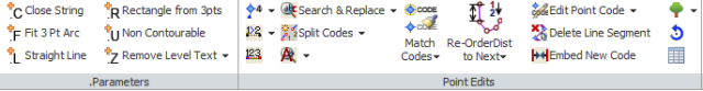

Stringer also fully supports menu and command line inputs.
Defining Contourable Points
Defining which points to use for generating contours can be problematic in many applications. Stringer TOPO provides a simple form that allows you to use wild cards to define contourable points.
Building Surfaces
Stringer TOPO uses the same powerful surface engine as Civil Site Design. You have all of the tools you need to specify contour intervals and colors, manage your TIN and analyze elevation and slope ranges.
Connecting Survey Codes
Stringer gets its name from its ability to automatically connect (string together) individual survey codes based on field or office defined connection numbers. This intuitive interface allows you to quickly connect field codes and generate both 2D and 3D breaklines.
Crossing Breaklines
Finding crossing breaklines cannot be easier. A single menu pick identifies all crossing breaklines allowing you to make the necessary corrections to ensure proper contouring.
Those Tricky Curb Returns
Many survey packages allow users to create 3 point curves for curb returns and other curved features. Stringer Topo improves on this process by automatically creating an updated TIN for that more accurately reflects the associated surface.

3 Point Building Outlines
Although pretty standard, this functionality reduces the time an effort required to capture and draft building outlines. These outlines can then be used as breaklines to eliminate contours passing through buildings.
Re-order /Connect Points Based on Distance
This is a really nice feature. Often, crews accidentally pick up points out of sequence creating on screen spaghetti. This function reorders the points automatically based on the distance from a user specified point.
Manual Traverse Support
Not all survey data comes from instruments. Stringer TOPO provides a form for manually entering field notes and survey plat information.
Utilities
In addition to the standard survey functions, Stringer TOPO contains dozens of specialty routines to assist in detailed drafting and labeling.
